


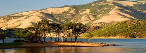


Mountain Lakes
discover a wilderness paradise
Select from the categories below.
Ashland is the perfect basecamp to explore Crater Lake and beyond!
Welcome to the Mountain Lakes and the Rogue River. The Mountain Lakes provide boating, swimming, fishing, camping, equestrian camps and many access points and day use areas. They include Crater Lake National Park, Hyatt Lake Resort and Recreation Area, Howard Prairie Resort, Lily Glen Campground,Emigrant Lake, Lake of the Woods, Fish Lake, Fourmile Lake and Willow Lake.
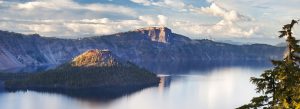
Crater Lake National Park
Celebrating 100 years of National Parks in 2016, Oregon’s only National Park is a 1.5 hour drive from Ashland making it the perfect day trip destination to southern Oregon’s landmark that welcomes 750,000 visitors annually from around the world.
At 1,943 feet, Crater Lake is the deepest and clearest lake in the United States and the ninth deepest in the world, holding 4.6 trillion gallons of water. Crater Lake was formed 7,700 years ago, when Mt. Mazama, a volcano, erupted in a cataclysmic eruption. During this eruption, so much material was evacuated from the internal magma chamber that afterwards, there was not enough left to support the remaining mountain. It collapsed and created the caldera that we now see today, half filled with water. Over many years, rainfall and snow melt filled the caldera leaving the intense blue water. The lake was originally named “Deep Blue Lake” by local Native Americans who revered it. In June 1852, prospectors hunting for gold, led by John Wesley Hillman, stumbled upon it. President Theodore Roosevelt declared it a national park May 22, 1902 making Crater Lake the fifth oldest national park.
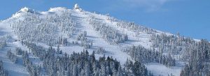
Cycling the Scenic Bikeway: The Cascade Siskiyou Scenic Bikeway incorporate 5,000 feet of steep and winding climbing through oak savannah into fir forests, showcasing the ecologically diverse ecosystem of the region. The 55-mile Scenic Bikeway starts in Ashland and the route skirts the edges of the Cascade-Siskiyou National Monument along the way, a region so ecologically significant that 62,000 acres of it is designated.
The route climbs oak-dotted mountainsides with views of the Rogue Valley and of Pilot Rock, a 25 million-year-old volcanic plug, standing over the valley on the Siskiyou Pass. In the spring w3wildflowers and red-tailed hawks can be spotted. Above the oak savannah, the Bikeway enters the Cascades ecosystem, with tall pines and Douglas firs providing welcome shade on the way to the 4,551’ Greensprings Summit. Riders can opt for a 5-mile out-and-back to historic Tub Springs State Wayside, where they can fill water bottles from a cold, pure mountain spring, just as emigrants traveling the Applegate Trail did in the 1800’s. Tub Springs is open year round and has restrooms.
Near Hyatt Reservoir you’ll see views of the 9,000’ Mt. McLoughlin, with glimpses of osprey and bald eagles nesting. Nearing the top there is one final 3-mile climb through the wildflower-covered alpine meads of Lily Glen and Buck Prairie before a winding 13 mile descent back to Ashland.
Bike campers can plan a two-day adventure by staying at one of the campgrounds near Hyatt or Howard Prairie Lakes.
For a shorter ride, many cyclists enjoy riding up the 3,000 feet to the Greensprings Inn for a meal and returning the same route which is a 35-mile ride round trip.
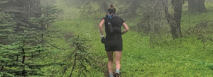
Recommended Day Hikes:
- Pacific Crest Trail – access to the PCT provides opportunity for day hiking at elevation from the CSNM through to the mountain lakes. Parking can found at the juncture of the PCT, CSNM and Hwy 66 when you get to the crest of the road at mile marker
- Cascade Siskiyou National Monument CSNM – one of the top 13 most bio-diverse regions in the world, 62,000 acres designate for a safe, low-impact experience. The primary way to enjoy is on the PCT. For access points visit www.BLM.gov or visit the CSNM info center is located at Hyatt Prairie Road and GreenSprings Inn, a Bike Friendly Business. www.rideoregonride.com
- Grizzly Peak Loop Hike – On the peak northeast of Ashland, the trail begins on BLM Road 38, 6.6 miles in off of Shale City Road off Dead Indian Memorial Road. Keep turning left at each junction then the road dead ends into the parking area. Trail Elevation starts at 5,200’ – ends at 5,747’with scenic overlooks and moderate grade. The loop is 2 miles one way and 3.5 miles if you do the entire loop. The trail is open to hikers, horses and mountain bikers. Spring to Fall. North facing slope portion of trail is snow covered in winter and requires snow shoes and gear. Always carry water! Trail travels through woods and meadows, reaches trail junction at 1.5 mile. Keep straight ahead, a short distance to an overlook that gives views of Mt. Shasta, CA, Black Butte, Mt. Ashland and Pilot Rock. At that same junction you can also continue left (south) and follow the trail along the rim-top to another viewpoint with views of Ashland and the Siskiyou and Cascade mountain ranges. The Loop trail leads you back to the trailhead. Due to high fire danger, no fires are allowed. In 2003, the East Antelope fire burned over the northern flank of Grizzly Peak as you can see from the scorched landscape along with the ecosystem that is naturally rebuilding itself. Due to the elevation, poison oak, ticks and snakes are not in the area.
Hyatt Lake Resort and Recreation Area
Nestled in the northern corner of Cascade-Siskiyou National Monument, the Hyatt Lake Recreation Area is generally open for camping from May through early October. Hyatt Lake Recreation Area has three campgrounds. The main Hyatt Lake Campground has 54 campsites, ranging from small RV sites to drive-in and walk-in tent sites. Wildcat Primitive Campground has 12 campsites and Horse Camp Equestrian Campground has 5 sites. One designated campsite for Pacific Crest Trail hikers is also available. The Bureau of Land Management's Hyatt Lake Campground is part of the Recreation.gov campground reservation system. The reservation system allows visitors to reserve individual campsites for Loops, A, B, C and Wildcat campground. Day use and Campsite fees apply. For more information please call (541) 482-2031 or (541) 618-2281.
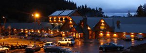
Howard Prairie Resort – a Bike Friendly Business
The Howard Prairie Resort is 155 beautiful acres, including 1.63 miles of lake frontage and breathtaking views of Mt. McLoughlin. The lake waters are teaming with both trout and bass and has some of the best fishing in Southern Oregon. The Resort offers everything from tent sites to large RV sites, a store, restaurant, laundry facility and full service boat marina. Daily fishing licenses are sold in the Lodge building during hours of operation. Annual fishing licenses should be purchased as Sportsman’s Warehouse, Blackbird or Bi-Mart prior to arriving at the resort. You can also purchase your fishing license online through Oregon Department of Fish and Wildlife.
The restaurant, store, marina and campground typically are open April through October. Camping and Cabin Reservations accepted online or by phone with a Maximum of 9 Months (to the day) in advance of the season. Please check lake water levels as with our drought they vary.
Horse Camp at Lily Glen
This popular equestrian park/campground is utilized by equestrian groups from all over Oregon and Northern California. There is a small stream to cross in the summer (larger in early spring), but most horses can cross it with no problems. With various trails, a campground with corrals in every campsite and two group camp areas with additional corrals, this equestrian park is the perfect place for a quiet afternoon ride and a great place to camp for the night under the stars. Lily Glen Equestrian Park/Campground at Howard Prairie Lake covers a total of 40 acres, including wonderful, easy, riding trails. You can ride around the shore of Howard Prairie Lake or just wander on the many unmapped trails.
Individual Campsites at Lily Glen Park are first come, first served. No Reservations. If your group is interested in reserving one or both of the Group Camp Areas, Reservations are required and made by contacting the Parks Office at (541) 774-8183 For more info go to www.jacksoncountyor.org
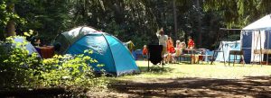
Emigrant Lake Park, Campground and Waterslides
As one of Jackson County Park's most popular destinations, Emigrant Lake has it all. Located just minutes from downtown Ashland, Oregon, the park offers a host of activities for the entire family. Emigrant Lake is a local oasis nestled between the hills of Ashland and a great opportunity to get away from it all without having to go too far from home. With 1467 expansive acres, including 12 miles of lake frontage, Emigrant Lake offers various recreational activities including RV/tent camping, fishing for bass, crappie, trout, boating, canoeing/kayaking, water skiing, swimming, picnicking, hiking, playing on the playground, or sliding down the refreshing 280-foot twin flume water slide.
Set up your family reunion, company party, school group function, or wedding reception at one of our four covered Group Picnic Areas. All areas offer electricity, tables, barbecues and nearby restroom facilities. Group Picnic Areas can accommodate from 125 - 300 people and are available to groups from 10 am to sunset. Whether you want to be close to the water, by the boat ramps, near the campground, next to the water slide or playground, one of our picnic shelters will be ideal for your group. Group Picnic Area Reservations are not required, but recommended, and must be made by phone through the Parks Office. Day use park fees are approximately $4 per vehicle. There are 3 boat put ins identified on the map.
The Point RV Park features 32 sites with full hookups, overlooking beautiful shoreline on the lake's north end. Each site offers water, 50-amp electrical service, sewer, and 14' x 50' pads to accommodate larger RV's. It is open all year. For a more natural experience, set up camp in one of the 42 tent sites at the Oak Slope Campground open April through October. All campsites include a campfire ring and picnic table and a nearby restroom/shower building in both areas. RV Park and Campground Reservations are recommended but not required, and may be made online or by phone through the Parks Office, 15 calendar days to 9 months in advance of the first night's stay. Firewood bundles are available for purchase. For prices and reservations go to www.jacksoncountryor.org
If you require a larger space, be sure to utilize the Group Campground area, which can accommodate up to 100 people. Group Campground area offers several picnic tables, large campfire ring, standing barbecue, horseshoe pit and a restroom/shower building nearby, making it a perfect spot for a family reunion, business retreat, or any larger social gathering. Group Camp Reservations are required and must be made by phone through the Parks Office.
Sky Lakes Wilderness
Sky Lakes Wilderness is a land of lakes, rocky ridges and timbered slopes, and was designated by Congress in 1984. Its 113,590 acres straddles southern Oregon’s Cascade Range from Crater Lake National Park southward to Highway 140. It is approximately six miles wide and twenty-seven miles long, with elevations ranging from 3800 feet in the canyon of the Middle Fork of the Rogue River to a lofty 9495 feet at the top of Mt. McLoughlin. More than 200 pools of water, from small ponds to lakes of 30 – 40 acres, dot the landscape. Fourmile Lake, near the southern end of the area, exceeds 900 acres. The lake basins can sometimes be crowded with other campers, but the wilderness has thousands of acres of forest and scenic ridges where the visitor can find solitude.
Willow Lake Campground and Yurts
Willow Lake, at 3,014’ elevation is a wooded escape set at the base of Mt. McLoughlin, just 7.5 miles east of the City of Butte Falls, Willow Lake is a short drive with great views. With an expansive 927 acres, including 4.4 miles of lake frontage, recreational activities include hiking, swimming, fishing for trout, bass or crappie, camping and boating. Open year round, each of the four cabins at Willow Lake offers two bedrooms, a bathroom with shower, a dining/living area, and a kitchen. For a more traditional experience, set up camp in one of the 32 tent sites or try one of the 31 hookup sites to keep your stay as relaxing as possible. All sites come complete with campfire ring w/grate and picnic tables and restroom/shower building is nearby.
If you require a larger space, be sure to utilize the Group Campground area with its 11 sites, and can accommodate up to 150 people and 15-20 recreational vehicles, making it a perfect spot for a family reunion, business retreat, or any larger social gathering. For the best of both worlds, try one of our brand new cozy Yurts. Each of our two Yurts are furnished with a full Futon sofa, one single/double-sized bunk bed, coffee table, outdoor campfire ring w/grate, picnic table, and a locking door. Reservations are required for cabins, group campground and yurts. They are recommended for camp sites. Reservations may be made online or by phone through the Parks Office, 15 calendar days to 9 months in advance in the first night’s stay.
Fourmile Lake
Fourmile Lake is located off Highway 140 near Lake of the Woods. The campground and day use area is at the southern end of Sky Lakes Wilderness area. Horse corrals are available in the upper portion of the campground and the proximity to the wilderness and Pacific Crest Trail make it ideal for the backcountry enthusiast. The wilderness has gentle, densely forested terrain with occasional steep areas. The name derives from the many small lakes, most of them clustered in several glacial basins near the crest of the Cascade Range. Several species of trees including Shasta red fir, western white pine, mountain hemlock, lodgepole pine, Engelmann spruce and white bark pine are found throughout the area. The forest's understory is dominated by species of huckleberry, as well as manzanita, snowbrush, and heather. Visitors to the area will enjoy a variety of activities including hiking, backpacking, climbing, kayaking, canoeing, rafting, horse packing, bird watching, stargazing, fishing, and horse camping.
The campground is equipped with hand-pumped water and stock-loading facilities, picnic tables, campfire rings, vault toilets and boat ramp. Sites are available on a first-come, first-served basis. Look for improved boat trailer and passenger vehicle parking in boat ramp and day use areas. Please follow directional signage and park in a responsible manner.
Lake of the Woods
Southern Oregon’s Playground and Vacationland has just got even better. Lake of the Woods Resort operates the Forest Service Campground with public camping and day use facilities. The day use fee is $5 per vehicle. There is a universal season pass for Lake of the Woods and Fourmile Lake for $40. This high mountain historic family and fishing, lake resort sits beside one of the clearest natural lakes found in the Southern Oregon Cascades. One can enjoy cabin life, comfort food, the wonders of nature, and a variety of outdoor recreational activities. Waterskiing, Fishing, Fly Fishing, Sailing, Hiking, Boating, Scuba Diving, Camping, Canoeing, Paddle Boats, motor boats, or lounging on a pontoon boat from our rental fleet, Summer Lodge Dining, and Championship Golf Courses Nearby. The Summer Lodge Restaurant & Bar that overlooks the lake is the hub of the resort serving breakfast, lunch and dinner 7 days a week. There are 34 Cabins that offer historic charm, some with gas stoves, all with bathrooms and kitchenettes. The Marina includes a gift and apparel shop, sundries, tackle, fuel, upgraded rental fleet, moorage, and exclusive resort’s boat ramp. 36 boat slips available for rent Seasonal, Monthly, Weekly and daily spots available. Marina Pizza Parlor offers dockside dining and takeout, open every day at 11 am in the summer. Summer General Store is open mid-May through mid-September and offers a wide selection of food and merchandise. 22 RV Sites offer wooded spaces available with hookups, daily and extended rates. Pack a picnic, take a dip and enjoy!
Fish Lake Resort and Campground
In the midst of an old growth forest Fish Lake offers some of the best fishing in the area. A boat launch for Fish Lake (10mph) is within the campground and many amenities are offered at nearby Fish Lake Resort. The resort encompasses 17 campsites, 3 walk in tent sites, a campground host, drinking water, 3 flush toilets with wash basins, garbage disposal, gray water sumps and firewood for sale.
Top Recommended Hikes and Trails;
Include High Lakes Trail, Brown Mountain Trail, Mt. McLoughlin Trail, Fish Lake Trail, Rye Spur Trail and Badger Lake Trail.
- High Lakes Trail starts at Fish Lake Hwy 140 milepost 30 and ends at Great Meadow past Aspen Point Campground near mile post 37 on Hwy 140. Easy for hikers/bikers between Great Meadow and Brown Mountain trailheads. Moderate for hikers and bikers between Brown Mountain and Fish Lake trailheads. Bikers are not allowed on the PCT. Trail is in season May through October. It connects to the family loop, Sunset, Pacific Crest and Fish Lake trails. From Fish Lake boat ramp area elevation of 4634’ to Great Meadow rest area is 9 miles ending at elevation 4949’. The trail travels through 2.5 miles of lava flows and groves aspen and fir. You can also experience views of Mt. Mcloughlin and Pelican Butte. Interpretive signs indicate geological, wildlife and botanical features. If you choose to do the one way route, with a car shuttle, it is easier to begin at an east trailhead such as Lake of the Woods that is more than 300 feet higher than Fish Lake. Carry water!
- Brown Mountain Trail is 6.8 miles long and runs from the junction with High Lakes Trail on the Fremont-Winema National Forests to Forest Road 3705 on the Rogue River-Siskiyou National Forest. The summit of Brown Mountain is 7,311’. The trail can be accessed by hiking, mountain biking or horseback along the southern flanks for Brown Mountain. Passing through a shaded old growth forest, the trail offers opportunities for Morel mushroom hunting in the last spring; shade loving wildflowers such as orchids and trilliums, blanket the forest floor in early summer with good huckleberry picking in late summer followed by brilliant fall colors. Beginning on Forest Road 3705, the trail follows the South Fork of Little Butte Creek. At 1.5 miles the trail crosses road 500 and continues through the forest along the creek, which now becomes swampy and abound with willows. At 2.5 miles you cross Forest Road 560 and 2.9 miles you cross the Pacific Crest National Scenic Trail. Mountain bikes are prohibited on the PCT. While the trail skirts the massive lava flows of Brown Mountain, the mountain is almost hidden by the forest. Between 3.6 and 3.9 miles the mountain and lava flows can be viewed through the trees. At 5.2 miles the trail forks: the trail to the left continues to High Lakes Trail (1.5 miles). Follow the trail to the right 0.1 miles to Road 3640. Bring water as water sources are untested and considered unsafe to drink.
- The Mt. Mcloughlin Trail is about 5 miles long via Mt. Mcloughlin Trailhead. You can also access this trail via the PCT trail on Hwy 140 at Mt. Mcloughlin trailhead parking or access from Summit Sno Park/Trailhead on Hwy 140 which adds a couple miles to the trail each way. Horses are not recommended on this trail. The trail is very difficult yet rewarding. It winds through rocky terrain to the summit of Mt. Mcloughin at 9,494’, the sixth highest Cascade peak in Oregon. After the trail leaves the PCT, at a point a little over a mile from the Mt. Mcloughlin Trailhead parking lot, the trail ascends through a boulder strewn forest. Watch for blazed trees and a well-worn path. Above timberline, marks spray-painted on boulders are unreliable. Once you reach the main rides, follow the ridge line up to the summit. Watch your footing and avoid the loose scree on the left. Be Aware: Each year a number of people become disoriented or lost on the way back down, usually due to coming down a different route than they used when climbing the mountain. Tempting as it may seem to descend the sandy, cinder slope, the lower you get down this slope, the further away you become from the trail and once down to the timberline, it’s a 2 mile strenuous boulder-hopping hike back east on to the trail. The safest way to descend is simply to follow the same ridge-line route that took you to the summit.
Climbing Tips: Be in good shape and have some experience with easier climbs; check the weather before you go and start early, it can take 4 to 6.5 hours to reach the summit. Plan on summiting by 1pm. Mt. Mcloughlin is in a designated Wilderness where regulations apply with Leaving No Trace. The maintained trail ends at the tree line. Traveling close to the ridgeline when above the tree line will help you return on the maintained trail on the way down. Keep Fourmile Lake in view while going down. When above tree line, if you can’t see Fourmile Lake you may be straying too far from the ridgeline to return to the maintained trail. - Fish Lake Trail is a moderate, 4 mile hike one way. Its accessible May through October for hikers and mountain bikers. The trail follows the north shore of Fish Lake past the resort and heads east through large openings of basalt lava. After 4 miles the trail ends on the High Lakes Trail and PCT can be accessed from the north fork campground off of 140 to Route 37 1 mile.
- Rye Spur Trail travels north of Hwy 140 and Lake of the Woods to Fourmile Lake. At the Junction of Hwy 140 and Road 3661, continue east on Hwy 140, .4 mile just beyond milepost 36, take an immediate right turn leading toward the trailhead. The one mile Billie Creek Nature Trail for hikers and horses only is located 1000’ up the trail and loops through sands of ponderosa pine, white fir and other coniferous trees. The Rye Spur Trail crosses Billie Creek in two locations. Decayed logs from past logging activities provide food and cover for wildlife. After passing Billie Creek Trail, Rye Spur Trail continues about 6 miles to Fourmile Lake Campground. Hikers would benefit mostly by hiking 3.4 miles from the upper trailhead to the viewpoint and return. From the viewpoint, there are views of Pelican butte, Mountain Lakes Wilderness and of the fault systems below, leading north into Sky Lakes Wilderness and south into California.
- Badger Lake Trail starts at Fourmile Lake campground and goes to PCT, then to Woodpecker Lake (1.3 miles), Badger Lake (1.7 miles) and Long Lake (3.7 miles). With easy grades it is accessible June through October. There is no fee required to park at trailhead. Parking area for all trails can be reached by turning left for .1 mile then left again to the parking area and trailhead. If accessing Mt. Mcloughlin from Fourmile Lake, hikers can follow the PCT south to the Mt. Mcloughlin Trailhead and onto the summit.